Archive | April, 2016

Day 93 – Greatest day ever

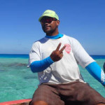
We awoke to Two Fish tugging strongly on her anchor chain in a 20 knot breeze, but fears of the Raroia anchorage being uncomfortable were put aside by a weather forecast predicting a lightening breeze throughout the day. We scrambled around the boat packing masks, fins, cameras, hats and sun cream. Our ride for the day was a local who was doing the island’s first foray into the tourist trade. He currently works in the copra business and pearl farming but was convinced to try this new venture. We had paid in advance so that he could buy gas for his 19 foot wooden motor boat. The boat is spartan and lacks seats but our guide offered a rope for additional safety. All doubts of the need to hold on were shaken out of my body when we bashed into our first set of bone jarring waves. Gail was wincing as she was convinced her spine was being compressed and that she might depart the boat standing less than 5 feet tall. Mercifully, the ride ended and armed with the knowledge that the return trip would be down wave we all bounced back very quickly.

After a short stumble into the woods we found a monument erected to commemorate Kon Tiki’s crash site. It had been paid for by a similar mission a decade ago with addition funding from the Norwegian government. I doubt the average Raroian could care less about the monument. How about a monument for the 100,000 Polynesians that did the trip upwind before modern maps! Thor sailed the easy way, which is also the route we are following.

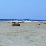
We then walked the fringing reef which is 350 meters wide (distance from the barrier island to the open ocean). The fringing reef covers the entire windward side of the island and is 20 nautical miles long. The fringing reef is between 10 to 40 centimeters under the water yet is full of marine life. Many baby sharks pass their childhood in these shallow waters. The sharks are easy to spot by their black tipped fin which is constantly out of the water. The sharks coast inches above the sharp coral, sea cucumbers and sand dollars (I renamed them “sand 20 dollars” because of their huge size). But the aspect of the fringing reef that captivated me was the line between reef and ocean. As we neared the end of the reef I could feel the powerful Pacific rollers that have traveled unimpeded for thousands of miles before being arrested by the reef. The dark blue ocean water called to me like the sirens in Odysseus, but I knew if I jumped in it would be sudden death. I would be pounded into shark food by the surf.

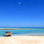
During the walk back from the reef’s edge I coined a new term for the clear water. Gin clear water is overused and I associate it with cloudier Bahamian water. In the Tuamotus the water is so clear you don’t need to put on a snorkel mask, just cast your eyes down and you will see plenty of fish and bright corals. So my new term is “can read a copy of the New York Times placed on the bottom clear water”. I am not sure it will catch on.

Pass dives are one of the reasons cruisers come to the Tuamotus. The basic idea is to jump in at the beginning of the pass at slack water before the flood tide. Then descend to the bottom and get swept back into the protection of the atoll. Simple plan but this was my first pass dive so I was excited when a cruiser, Chris, decided to join (baby sit) the two rookies. This was the greatest dive ever! We dove quickly into an area with many large grouper and reef sharks. We stayed for a short while by holding onto rocks at the bottom, but soon the current started to flood harder and we let go and rode the marine roller coaster ride. For the next 15 minutes we traversed the pass; it felt like another planet. I kept thinking about how different this crossing of the pass was from 24 hours earlier on Two Fish. Both kept me plenty busy. The bottom is covered in corals of many types for as far as the eye can see. The complete coral coverage of the entire bottom is vastly different from my Caribbean dives. The bottom of the pass has a winding canyon which the current pushed us through. Some of the turns were a bit sharp so a few well timed fin kicks were required to navigate the turn before plowing into a wall of coral. A glance above to the water’s surface showed long white lines, evidence of the standing waves that boats would encounter on a passage. I quickly returned my focus to the immediate surroundings. The tapestry of marine life is vast but I was going too fast to appreciate any meaningful percentage of it. Chris was in front and had slowed down but I was struggling to stay behind. I experimented with different body positions to decelerate. Eventually, I realized that 2 feet deeper the current is much slower. I wasted a bunch of air kicking hard with my fins so I checked my air gauge frequently to make sure I would have enough air to complete the final portion of the dive. Grouper and Sharks still featured prominently and a host of other wonderful creatures swam by but it was the endless coral that captivated my attention. We surfaced and thankfully the greatest day was not yet over.

“C’est tres blanche” (it is very bleached) is what our guide said on the return ride home. He was referring to the coral bleaching caused by the high sea temperatures of El Nino. When coral becomes stressed it releases acids that kill the algae that create coral’s protective cover and coloration. The coral then turns white without this protection and soon dies. The grouper population then drops and the only fish that remain are not safe to eat. This is a crisis for the island since they fish to eat. New food sources not quite to our taste come onto the menu.

Chris told me an amazing story. Chilean fisherman create simple rafts with the purpose of setting them out to sea. Over the course of many months, the raft grows plants, then attracts small fish, then medium fish and finally bigger fish join the ecosystem. The raft has a cheap plastic ball with rechargeable batteries, a solar panel and a satellite text messaging unit. The Chilean fisherman can track hundreds of these mini ecosystems and at the right time they follow the GPS track and pick up the raft and catch the fish. Throughout the year, many of these rafts are lost and Chris has a hobby of converting the parts into new things. A rechargeable flash light is popular with the locals.

A few months ago, the village was in a frenzy about the great news that the island was chosen to be a one-time stop for a cruise ship. A committee was established to set about the process of preparation. The islanders decided that to look their best a fitness regime was required and a basic weight-lifting station was created near the quay. As the day approached, brooms were pressed into service and all the island’s flowers were picked to adorn the locals and give to the guests. But the weather gods were not kind and the ship anchored outside the pass. The pass was rough and only 6 people of the hundreds on board came to shore. The village was crestfallen but the good news is that the fitness regime has continued.

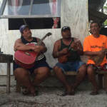
Back on shore, we strolled to Reggie’s which is Reggie’s home, far short of a bar. Reggie spins a good yarn not letting details like the truth hold back the drama. We were told about his ex-wife and his life on a western island in the Tuamotus, his creation and eventual loss of two pearl farms, and his attempt to populate the island with goats, chickens and pigs. The pig experiment was curtailed when the local dogs had a hankering for bacon. The chickens seem to lower property values as no one is harvesting the eggs, but sleep is cut short by the roosters. The magical moment of the evening was the music. I just relaxed without a concern in my mind enjoying the gentle voices of the singers, the cooling breeze and the sand under my feet.

How could a day be any better? I climb in the bilge to fix stuff for days like this. Thank you Raroia.

Photos: Our guide at the helm of his boat. Jason in the you can read the New York Times clear water. The fringing reef meets the open ocean.

Experimental Tourists by Gail

When you hear “Kon-Tiki”, you might have a vague memory of Thor Heyerdahl and his misguided attempt to prove that the Polynesian peoples are descendants of trade wind travelers from South merica. DNA tests have since proven him wrong. We encountered Thor in Rapa Nui, where he raised the fallen Moas, and elevated himself to rock star status (pun intended), and in Fatu Hiva, where he instead angered the locals, perhaps with his self-importance, and was eventually driven from the island.
His raft, propelled only by wind and oars, and launced from the West Coast of South America, eventually ended up on a lee shore in the Tuamotus. The Kon-Tiki crew were less enthusiastic about their arrival here than we were. Having successfully navigated the narrow pass at a less than optimal time, but with the expert guidance of Jason and Two Fish, we were excited to drop our anchor and enjoy the beauty of this coral atoll.
After chatting with our neighboring boat, who happened to be the couple who brought two goats with them on their passage, we were introduce to one of the islanders, Turamotu. He agreed to take us to “Kon-Tiki Island”, on the other side of the atoll, where we could see the reef that Kon-Tiki was finally impaled upon. It turns out that some of the islanders have been trying to figure out how to start a tourism business. There are only one hundred or so inhabitants and they only recently gained an air-strip with one small prop plane visit a week. Our day with Turamotu was to be his first attempt at showing visitors the beauty of Raroia. He was, of course, a natural. After walking with us on the edge of the reef, he took us to the most amazing snorkel spot. After our swim, we were greeted by freshly cut coconuts, the best I have ever had.
Later in the day, he and our sailboat friend, Chris, took Jason and Jim on a drift dive. Jason claims it is the best dive he has ever done.
But the day was not yet over. Another islander, Reggie, has a meeting spot on the beach, where people gather to chat and drink Hinano’s. Ever eager to please others, he agreed to join us in the evening and invite his ukulele-playing friends to provide the music. The day ended magically as we listened to the sweet voices singing along with the music. Music is participatory here, so four drums were also brought out for us; Reggie tried to guide us in playing the correct beat.
Once we return to the land of internet, I promise that we will spread the word of the beauty of Raroia, but I am secretly thinking that I on’t want to ruin the magic.

Photos: Our boat ride to the outer island and reef edge where Kon Tiki crashed. Trio of local singers make the evening magical.

Day 90 – Mountains to the Atolls

Landfall in the Marquesas was, for us, the beginning of our exploration of exotic islands. The Galapagos had choreographed crowds and Las Perlas had Jet Skis, both of which killed any sense of blazing a new trail. The vivid green palette of the Marquesan hillsides, the exceptionally welcoming people and the dramatic hilltops created a memorable two weeks. Unlike earlier explorers, we chose to explore Nuku Hiva in a manual transmission pick-up truck. After no discussion, I was elected driver, despite not having driven a stick in years. We stopped many times for hikes and “discovered” Tikis and other ruins. On the windward side of the island we stopped in a small village with friendly residents, spending their Sunday body surfing. In the local church, we read the hymn book in Marquesan and marveled at the beautiful wood lectern. A short stroll to the harbor revealed the dinghy dock from hell. The six foot swell would flip any dinghy and launch boat and occupants onto sharp rocks or hard concrete. The road became more difficult to drive as the day progressed. It narrowed, converted to rock and dirt soup and finally it became an impossibly steep stream. Gail finally convinced me that prudence called for a U-turn.

The next day, Jim and Theresa came aboard. They spent the day hiking to a waterfall that we had already explored. A good French word to know is “cascade” (waterfall). We did a few pre-passage chores: installed the Genoa that had had some stitching fail, replaced the wind instrument and 20-odd smaller items.

At 5:15 in the morning, the crew was woken up and we weighed anchor without issue. This gave us three and half days to travel 450 miles. We could have slept in but I like to be on the safe side since arrivals in the Tuamotus need to be scheduled with the light, tide and other variables.

The new skill we will develop in the Tuomotos is shooting the pass. The atolls have very strong tidal currents. They are driven by the moon, unusually large swell and winds stronger than 15 knots. The atoll has one or two gaps in the fringing reef. This creates a situation where the water is looking to exit, but can only return to the open sea through a small gap. The current can reach an astounding speed, challenging Two Fish’s top speed under motor of 9 knots. So, typical of Two Fish, we over-studied to determine our optimal strategy.
1) We downloaded a cruiser-built spreadsheet, the Guesstimator. It uses one island’s tidal data to calculate tidal data for all the atolls and passes. It also allows for adjustments due to winds and waves. I shared this sheet with our fellow rally members.
2) A non-rally boat friend told us the best passage time for our first atoll Raroia since he had entered the previous day.
3) We listened to an excellent teach-in on the passes given by a seasoned Tuamotus cruiser. His advice is: a) Always enter the pass in good light
b) Wear polarized lenses to see coral
c) Tack in front of the pass to look for standing waves. Use binoculars. d) If current is a problem, you may find relief close to the edge. e) Wait and try later if the pass seems too tough.

So our final exam arrived after a gentle three night passage. The wind and waves were light, setting us up for an easy transit. We were sailing at ambling speed to time our entry, when I heard the boat Silent Sun on the radio. I spoke with them and they gave me the advice that the pass should be fairly tame due to the light winds on that day. We decided to enter the atoll early. I was tentative at first and tried to find the calmest spot. Dead center was covered with some standing waves of small size (less than 3 feet). Crew were positioned at the bow looking for coral heads but the water was too rough and deep to see much. Gail was tracking our progress on Google Earth as another technique to look for coral heads. Lastly, we used our iPad Navionics charts, which are superior to the chart plotter’s C-map charts for this group of islands. I continued to push the boat farther into the pass. The rough waters did not rock the boat, however, they caused Two Fish to turn off course. I over-corrected with the helm and then corrected again. We were traveling in a crab-like walking pattern or maybe the course of a drunk coming home from the bar. After ten minutes, the pass waters became more stable but the tidal current grew stronger. I increased the engine revolutions to 2,200 (standard cruising speed). Our speed through the water was 7 knots but our speed over ground was 2. We were walking up fast but we were on the down escalator. The current was pushing us out to sea at 5 knots. I was enjoying the pass, so I did not speed up the boat. The tidal stream continued to strengthen and I responded with more engine power. Many times the boat’s speed over ground dropped to zero as the current was just as strong as the engines. 7 knots of current would dominate any swimmer, canoer and many small outboard motors. Two Fish was totally fine. Engine temps were staying at normal and we had plenty of extra power. The pass was fairly wide but we still followed the navigation aids. We lined up two large range markers to ensure we were in deep water. After another ten minutes, our speed over ground started to increase indicating our passage of the strongest current was complete. We took a hard turn to starboard, and followed a well-marked channel. We were no longer rookies of atoll passes. We had crossed at peak ebb, an exception to the rule because of the circumstances, but it was great experience for future passes.

Photos: Gail before leaving the green Marquesas. Jim and Theresa catching a fish on passage

jason

Two Fish Sailing mid ocean

Photos were taken by Hannah of Blue Summit.  Thanks!  They were taken 1,500 miles from any land on our way to the Marquesas.